StansWeather.net

Review: WeatherWall Mobile

Company: WeatherWary, LLC
Name: WeatherWall Mobile
Platform: iPhone / iPad / iPod Touch (universal app)

Back in November 2011, I was contacted by the folks at WeatherWary asking if I would review their new radar app. I said sure, but promptly got sidetracked. Better late than never, I wanted to complete my promise to them. Not only did I write a review but I also created a short video so you can better see the app.

https://youtube.com/watch?v=qbpH6Ahs3LM

WeatherWall Mobile is a radar app for the iPhone, iPad and iPod Touch. Being a weather nerd, I have a lot of radar apps on my iPhone. This one is on the first page of my weather apps folder and gets used a lot. For PC users, it reminds me of the GRLevel3 software. It downloads raw radar data and generates the radar image instead of other apps that download static weather map images. The result is a much higher resolution image that allows you to zoom in. The smoothing option is nice as it makes the radar a little easier to see. (it can be turned off)

Another nice feature is the ability to filter out various DBZ levels from the radar. During severe weather, I filter out the lower DBZ so the higher returns show up better. If you are looking for outflow boundaries or light snow, it’s best to turn off filtering.
weatherwall mobile
A lot of radar apps will show you the warning polygons, but WeatherWall Mobile allows you to tap a small dot on the warning and view the actual warning text. This contains various information like towns impacted, type of damage expected, hail size, wind speed, etc.

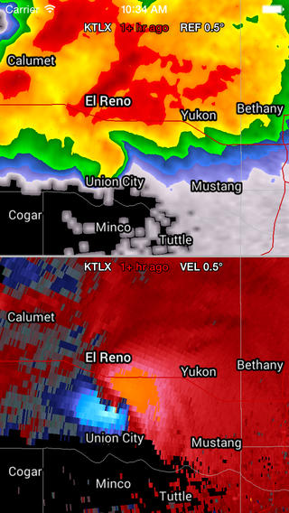
One of my favorite features which sets this apart from other radar apps is the ability to see two different radar products at the same time. (swipe in any direction with 2 fingers) I often use this to show both reflectivity and velocity images at the same time. Very powerful feature, especially in a mobile app.

Other features include Spotter Network integration (positions/reports), severe local storm reports, GPS location, entire US radar image, dual-polarization radar products and topographic background.

If you are a weather enthusiast such as myself, then you need this app. Click the button below to go to the app store and purchase this app.

My Dust Devil on the Weather Channel

About a month and a half ago, I was contacted by a producer inquiring about using my dust devil video from March 31, 2000 for an upcoming show on the Weather Channel. I’ve been contacted in the past, but nothing has ever made it to television. I found out today that they will be airing the video this Sunday (9/29/13) at 7:00pm central / 8:00pm eastern on the Weather Channel’s ‘Caught on Camera’ series.

Apparently this episode is all about dust devils so I am anxious to see how they use my video. Unfortunately I do not have cable so I will not be able to watch it live. However, they will be sending me a copy of the show so I will eventually get to see it.

If you are able to watch this episode, please let me know how it turned out. Thanks!

Update: (10/8/13) Apparently this episode aired a week later on 10/06/13. It was season 4 episode 6 labeled Close Calls. It will air again on October 16th at 2:00am-3:00am if you missed it. So far I have not found a copy online to share. I received a copy of the episode on DVD today and watched it. They showed my dust devil video right after the dust devil researcher clip. Pretty spiffy!

May 25, 2011 – Moderate risk chase in central Illinois

It’s been a crazy year for storms except here in central Illinois. The amount of large cities virtually wiped off the map has been unbearable. The death toll is also really hard to grasp right now. Just this week alone we had Joplin, MO take a hit from an EF-5 tornado on Sunday and then numerous large tornadoes in Oklahoma on Tuesday. When I woke up Wednesday to a moderate risk, I started to get concerned. I thought that our luck had run out and mother nature was going to bring her destruction to Illinois. I love chasing storms, but I definitely wanted no part of that nightmare scenario.

All morning we had storms roll through the area. The concern was that the morning stuff would prohibit the afternoon stuff from being able to reach their full potential. By mid-afternoon, storms were moving into IL and triggering tornado warnings. I was stuck at work till 4:00pm, so I decided to pick a target closer to home. I was keeping an eye on storms firing up north of I-70. They seemed to start out promising, but then died out quickly as adjacent storms fired up. While this was disappointing, I decided to go for it anyway.

After fueling up for gas, I departed Champaign at 4:30pm. I headed west on I-72 towards Decatur. The initial plan was to drop south of Decatur to intercept what I was hoping would be a decent storm. Unfortunately, my promising little storm had dissipated into a brief shower. I noticed more storms firing up further east and south, but I was really out of position. The storms west of me were all jumbled together so seeing anything would be pretty slim. I got stuck in Decatur for a little while trying to find my way to IL 121. I finally made my way to the north side of Mt. Zion and pulled over to observe a storm. This same storm had been tornado warned earlier, but it got downgraded to a severe thunderstorm warning once it moved into Macon county. Other than a few seconds of very small hail, the storm didn’t do anything.

I decided to turn around and head back north to US 36. The storms coming in from the west were starting to move in and a nice shelf cloud had appeared. I jogged east on US 36 and pulled off the road on S. Prairie View Road. (6:07pm) I let the shelf cloud come to me and it was quite a nice sight. The wind started picking up as did the rain, so I headed north and east to stay in front of it. As I approached IL 105 and E 400 North Road, the winds increased considerably from the southwest. I decided to pull over at this point and shoot some video. (6:24pm) I didn’t have time to hook up the anemometer, but I estimated the winds to be around 50-60 mph. (It was rocking the Jeep pretty good!) The high winds combined with the heavy rain was reducing visibility to almost nothing. A few minutes later I heard hail slapping the back of the vehicle. Normally I’d stick around to see how big the hail got, but with this much wind I wasn’t taking any chances. I headed east as best I could in the blinding rain and then north on N 500 East Road. The winds and rain were coming straight from the west now so I was getting slammed. I found a spot to pull off across the street from a large outbuilding which was reducing the impact of the wind. (6:35pm)

I continued east and north towards Monticello. A tornado warning was issued for Piatt and Champaign county at 6:53pm. A few minutes later I heard some traffic stating that a tornado had been reported near Seymour and it was heading towards Champaign. *gulp* I hopped on I-72 and hightailed it back to Champaign. Thoughts of all those cities getting destroyed earlier in the week popped into my head. As I got back to Champaign, I headed home to make sure there was no damage. All was well at the homestead as well as everywhere else I looked. *whew!* I called a few friends and relatives and everyone was good. I was impressed that most of the people I talked to took shelter in their basements (if they had them) when the warnings went out.

Final Thoughts
I think I was more relieved that mass destruction didn’t occur vs being upset that I didn’t see anything spectacular. It was a nice local chase and was good to get back out there again. Hopefully we can get some less violent weather in the next few weeks. I’m due for a good mammatus cloud display sometime soon. 🙂

Total Mileage: 127 miles

Video

https://youtube.com/watch?v=RAiwiWG4vbI

Review: Andrew Pritchard’s PWX 2010 DVD

Before I get to the actual review, I wanted to point out a few general observations about Andrew Pritchard’s storm videos.

Storm chasing is expensive
Unless you’re lucky enough to have a cable network paying your way, then chasing is usually funded out of our own pockets. His DVD’s are inexpensive and a great value in my opinion.

He chases Illinois
Like myself, Andrew mainly chases Illinois. He gets away to the plains when he can, but most of his chases are right here in Illinois. There’s a gazillion chasers in Oklahoma, but a much smaller percentage in Illinois. It’s nice to see video from my home state especially on days that I am unable to chase.

Limited narration
I have seen a lot of chase videos over the years and a lot of them are degraded by the excessive talking, yelling, and cussing in the audio. (I’ve unfortunately been guilty of this a few times) You don’t get that with Andrew’s video. There may be a few occasions where there will be other chasers near him being picked up, but for the most part he lets the storm do all the talking.

As for my thoughts on the PWX 2010 DVD… I think it is probably his best one yet. Sure his 2010 stuff might not have been as intense or numerous as other chaser videos, but he made the most of what he did have. Throughout the video he provides numerous time lapse videos with a wonderful soundtrack to fit the scene. I was a little apprehensive about him including non-2010 chases in this video that were covered in previous videos. For chasers who compile annual DVD’s, it’s nice to only see stuff from those years. However, Andrew didn’t just include the same video from previous years. He re-edited them to provide more details, contrast enhancement, as well as time lapses of the storms. He concludes the DVD with impressive still photos which really demonstrates his photography skills.

Stan’s recommendation: Buy PWX 2010! It’s only $15 with free shipping. Support Andrew’s chasing passion and buy the DVD!

For more details and ordering information, visit his website: PrairieStorm Media

Video Preview

https://youtube.com/watch?v=P6d-JwYdBY0

October 26, 2010 – Late season chase in eastern Illinois

I haven’t chased in October in a long time, so I was very interested in today’s setup. All the forecast models were predicting a near record low pressure so it definitely was worth paying attention to. The SPC had issued a high risk east of here and we were right on the edge of the moderate risk. Unfortunately the timing of the system would bring the storms through in the early morning before there was any daylight. Nevertheless, I was anxious to chase one more time this year.

I woke up around 4:30 in the morning and a line of storms were moving across Illinois. I departed around 5:00am and headed west on Rt 10 just west of the Champaign/Piatt county line. I put my anemometer on the roof and was surprised that it still worked. 🙂 I was only getting winds in the 20-23mph range though so think it might have been on the low side. I waited and waited, but I didn’t get much to write home about. I decided before it completely passed me that I would head back to Champaign and wait it out. I went up to Parkland College and shot some video of trees and lights blowing in the wind. It was almost 7:00am and I was about to call the chase a bust.

However, I noticed some of the lights towards the buildings go out while simultaneously seeing a blue power flash in the rear view mirror. I saw a few more flashes, so I quickly turned the car around to get a better look. A few seconds later, I was slammed with a wall of water and measured a 56.8mph wind gust. It didn’t last very long at all, but was pretty exciting. On the way back to my apartment, I discovered our dumpster was sitting in the middle of the road. I was going to call it in, but I heard the police mention it on the scanner. The major damage in Champaign was located in the 3200 block of Edward Hoffman drive which was just a block to my southwest. (see the News Gazette article for more info on that damage)

Final Thoughts
It didn’t last very long here but it was pretty exciting for late October. I must have just been on the edge of the microburst that hit the neighborhood to the southwest of me. The storm system also set a new low pressure record for a non-tropical system in the U.S. The NWS says that a pressure of 955.2mb / 28.21″ was measured in Bigfork, Minnesota. That’s pretty amazing!

Total Mileage: 30 miles

Video

https://youtube.com/watch?v=4opKVjMfgkM